
Last Updated on January 30, 2025 by Admin
Several civil engineering works are carried out in an unfavorable and complex environment, making it difficult for workers to operate efficiently. However, with the assistance of GPS, or Global Positioning System, the process is made easier. This blog post discusses GPS and its application to the construction industry.
ConstructionCareerHub App is LIVE — built ONLY for construction careers. Don’t apply with a weak resume.
Get ATS-ready Resume Lab + Interview Copilot + Campus Placement Prep (resume screening, skill gaps, interview readiness) — in minutes & Other advanced features.
Explore Smarter Construction Career Tools →Quick check. Big impact. Start now.
The Global Positioning System (GPS) has grown in popularity across a wide range of businesses. One of the industries that heavily rely on GPS data in civil engineering. Aside from that, it frequently entails working in a hostile and complex atmosphere, which makes it difficult for engineers to work efficiently.
GPS, on the other hand, gives real-time and reliable data, enhancing their output even in these severe conditions. Its capacity to deliver accuracy at centimeter and sub-meter levels at a low cost has substantially altered the civil engineering sector.
When the accuracy and free availability of GPS signals for timing and positioning are paired with cheaper receiver chipsets, GPS becomes one of the top recommended solutions for a wide range of applications in the civil engineering industry.
GPS systems provide centimeter-level accuracy in fleet management, earthmoving, and infrastructure construction. Wireless connectivity is included in these gadgets to aid GPS in gathering precise data.
Table of Contents
What is GPS?
A GPS tracking device communicates with satellites that are constantly sending signals to pinpoint locations. GPS systems can employ up to eight satellites at the same time. This ensures that the position estimate is accurate to within 100 feet.
Because construction sites are complicated, high-activity workplaces, this level of precision is required. Site managers cannot afford to lose time wondering where various assets are located.
GPS is basically a real-time positioning navigation technology. However, by converting ground-to-ground survey measurements to ground-to-space measurements made possible by GPS, this technique overcomes the numerous limitations of terrestrial surveying methods, such as the requirement of survey station intervisibility, weather dependability, difficulties in night observations, and so on.This integration also highlights the importance of PNT (Positioning, Navigation, and Timing) services, which ensure precise timing and synchronization crucial for the accuracy and reliability of GPS-based measurements.
GPS is the most potential surveying technique of the future because of its benefits over traditional techniques and the cost-effectiveness of operations. With GPS’s well-established high precision in positioning spots separated by a few hundreds of meters to hundreds of kilometers, this unique surveying approach has found major uses in a variety of sectors.
Related Posts:
- Textbooks and Reference Books for Advanced Surveying
- The ultimate guide to selecting a flooring material for your home
- Best Books for Advanced Surveying for Students and Engineers
- Top Quantity Surveying Courses | Quantity Surveying Institute In India [ Updated List]
Benefits of GPS in Construction
The GPS technology has numerous advantages in the construction industry which are as follows:
- The relatively high positional precision ranges from tens of meters to millimeters.
- The ability to calculate velocity and time with precision commensurate with position.
- Users can access the signals from anywhere on the planet, whether in the air, on the ground, or at sea.
- It’s a positioning system that doesn’t charge users and only requires the use of low-cost technology.
- It is a weather-proof system that operates 24 hours a day.
- The location data is three-dimensional, meaning it includes both vertical and horizontal information.
- It can be used on any type of platform, including aircraft (from jets to helicopters), ships, ground (from vehicle-mounted to handheld), and space (missiles and satellites).
- Capable of dealing with a wide range of dynamics.
- Capability for accurate real-time location, velocity, and time determination.
- The results of the positioning were supposed to be provided on a single worldwide geodetic datum.
- The highest accuracy should be limited to a specific user group.
- Unaffected by jamming (intentional and unintentional).
- Redundancy provisions to ensure the system’s serviceability.
- A passive location system that does not rely on the user transmitting signals to satellites.
- Capable of providing service to a limitless number of people.
- Because satellites are low-cost and low-power, as much complexity as possible should be put into the satellite portion.
- Complete replacement of the transit satellite and other terrestrial navigational aids.
Applications of GPS in Construction
Transportation services by Road
Different vehicles are used to deliver construction materials in the construction industry. The importance of timely delivery of those materials cannot be overstated. As a result, road transportation tracking becomes important.
In the case of road transportation, GPS applications include freight tracking, commercial fleet management, public transportation monitoring, taxi services, navigation and dispatch, emergency vehicle location, and passenger information.
Aerial Surveying
When it comes to commercial aviation, most aircraft now use GPS navigation, and it is commonly used for non-precision and initial approaches to airfields.
The Automatic Dependent Surveillance-Broadcast, or ADSB, is a future system for controlling air traffic that is being developed around the world.
GPS signals are also commonly used for the navigation of unidentified aerial vehicles. This is only intended for professional use, such as aerial surveying and resource mapping.
Rail and shipping transport
It should come as no surprise that both railways and shipping employ GPS navigation extensively. Inshore and ocean navigation, approaching ports, dredging, docking, and harbor entrance, AIS or Automation Identification System, VTS or Vessel Traffic Services, cargo handling, and hydrography are among the applications.
When it comes to trains, applications include passenger information, rolling stock management, cargo tracking signaling, stopping doors from opening until a carriage is beside the platform, train integrity, and level crossing approach.
Applications in science
Science and civil engineering are closely related, and both have applications that are widely used by people all over the world. These applications are numerous and include atmospheric monitoring, several animal behaviors studies, climate research, and meteorology.
When it comes to fisheries and agriculture, GPS signals are also employed to map the land area. It’s also utilized for yield monitoring, harvesting and spraying, precision crop planting, autonomous vehicle control, and fishing limit monitoring.
Security applications
GPS is also utilized for a variety of security applications, including the tracking of various vehicles, containers, and high-value items, as well as converting suspect tracking.
Guidance for the heavier vehicles
When it comes to civil engineering applications like construction and mining, GPS signals are increasingly being employed to guide and track heavier equipment. Consider the following illustration. Marker pegs and surveyors are replaced with an in-cabin vehicle navigation system and many control systems when a highway is being built.
These are found in graders, excavators, bulldozers, and a variety of road paving equipment, allowing drivers to follow surveyors’ pre-programmed and pre-planned site designs. This aids in achieving the tightest leveling, positioning, and gradient tolerances possible.
When it comes to open-cut mines, GPS signals have been integrated into a number of applications developed by a number of multinational corporations. Several mine asset management systems, as well as vehicle monitoring and guiding, rely on these.
The information from GPS signals is gathered by complex and high-end IT systems, which are then meshed with numerous other engineering applications to provide multifunctional control and guidance in these professional applications.
Mapping, surveying, and geophysics
Professional and survey-grade GPS receivers that can capture signals from the L1 and L2 frequencies of GPS are commonly used for positioning survey markers, bridges, buildings, and a variety of other major infrastructures.
These GPS signals are rapidly being employed in mapping applications, including aerial mapping and a variety of other GIS (geographic information system) applications.
When it comes to geophysics, GPS signals are utilized to time-stamp a variety of seismic activity as well as monitor changes in the position of sensitive physical formations such as earthquakes and volcanoes.
Financial services
Financial systems all across the world require precision timing systems for scheduling and prioritizing international and domestic money transfers, exchanges, and settlements, as well as maintaining a reliable audit trail for various financial operations.
Telecommunications
The timing of GPS signals is critical for a variety of telecommunications applications, particularly those involving mobile telephone networks. Synchronous technologies are far more effective than asynchronous technologies, but they require a specific time source that is accurate, reliable, and stable in order to operate efficiently. This effectiveness is aided by the GPS satellites.
Ground-based clocks are significantly more accurate for this, although synchronizing numerous of them can be difficult. By resolving signals from numerous sources of atomic clocks at known locations, GPS signals enable this derivation of synchronized time.
Environmental monitoring
Before starting a project, civil engineers keep a close eye on the surroundings. This is because the environment might have a good or negative impact on the project.
In addition, the government employs GPS to monitor pollution as part of its attempts to reduce pollution. Before beginning the project, civil engineers must ensure that the project will fit in the designated area.
Land Seismic Surveying
GPS data is crucial in oil and gas development. Civil engineers, for example, must first conduct subsurface geology in order to pinpoint the ideal drilling location. Civil engineers can also use marine seismic surveying to learn more about the composition of beneath rocks.
Sending low-frequency sonic radiation beneath the subterranean rocks accomplishes this. Seismic engineering encompasses both terrestrial and marine seismic applications.
Deployment of equipment/Machines
Large projects that rely on machines are common in civil engineering. The supervisors track the whereabouts of this equipment using GPS. They can also use GPS to deploy the equipment to different locations.
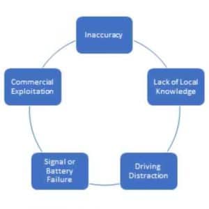
Limitations of GPS
The major limitations of the GPS in construction can be understood from the following diagram:
- The high cost of GPS surveys prevents them from reaching their full potential.
- Challenges in determining datum heights in relation to mean sea levels, as well as real-time data processing and control, are all part of the process.
- Global Positioning Systems (GPS) are often worthless indoors due to physical impediments such as walls and other things blocking radio frequencies. Furthermore, standard GPS can only locate positions within 3 meters.
- GPS cannot be used to follow the movements of retail consumers at a store and analyze their purchase habits, for example.
- To receive a satellite signal, GPS land surveying equipment requires an unobstructed view of the sky.
- Violations of function and communication can be hampered by dense foliage and other structures.
- Dead batteries and system malfunction can cause all GPS survey equipment to fail.
- Another issue is that the position can be drastically off from time to time, particularly when the number of satellites is restricted. Satellites employ atomic clocks, which are extremely accurate, however, there are occasional inaccuracies, resulting in time measurement mistakes.
- The satellites must retain their predetermined orbital positions, but gravitational influences (from the earth, moon, and sun) must be considered.
Conclusion
Global positioning system (GPS) technology has advanced quickly in the last two decades, and it is now being employed in a variety of businesses. At the moment, GPS measurement accuracy is limited, and the signal does not penetrate solid buildings or constructions.
The use of GPS as navigation, surveying, and information tool is promising since it can measure dynamic and static displacements in real-time, but traditional monitoring systems relying on other sensors such as accelerometers are unable to measure static and quasi-static displacements.
Furthermore, significant advancements in GPS devices and algorithms can limit the effects of erroneous GPS data sources, and integrated systems combining GPS receivers with additional sensors can offer precise measurements.
Related Posts:
- Expert Aerial Installation & Repair Guide: Tips and Tricks
- The Critical Importance of Cybersecurity in Construction Technology
- Top 100 Electrical Engineering Job Interview Questions and Answers
- Overcoming Common Challenges in Product Design and Development