Last Updated on April 3, 2025 by Admin
Welcome to the world of geospatial science, where mapping technologies open up exciting career possibilities! In this post, we explore the roles of Geospatial Specialists, Cartographers, and LiDAR Specialists. If you’re passionate about precision and innovation and are considering a Geospatial Specialist Career, you’re in the right place. Join us as we delve into the latest mapping technologies, essential skills, and dynamic career paths that are transforming our world.
ConstructionCareerHub App is LIVE — built ONLY for construction careers. Don’t apply with a weak resume.
Get ATS-ready Resume Lab + Interview Copilot + Campus Placement Prep (resume screening, skill gaps, interview readiness) — in minutes & Other advanced features.
Explore Smarter Construction Career Tools →Quick check. Big impact. Start now.
Table of Contents
1. Overview of the Geospatial Field
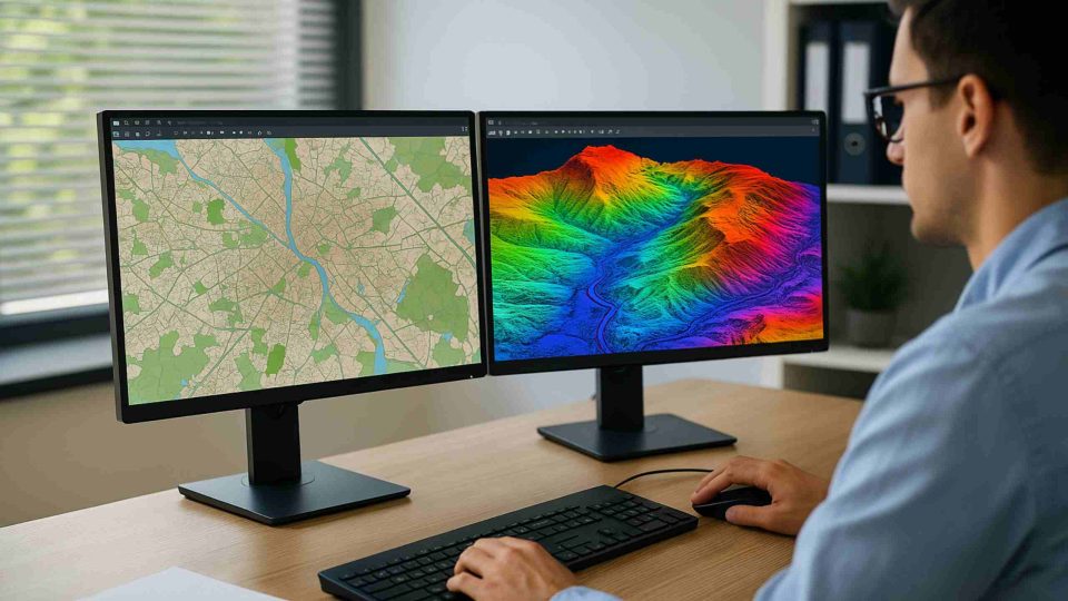
The geospatial field encompasses the collection, analysis, and visualization of data related to geographic locations. It is an interdisciplinary domain that brings together geography, cartography, remote sensing, and computer science. The integration of Geographic Information Systems (GIS) with remote sensing technologies has transformed traditional mapping into a dynamic tool for solving real-world challenges.
1.1 The Evolution of Mapping Technologies
Historically, maps were drawn manually, with cartographers meticulously handcrafting representations of the world. Today, modern mapping technologies leverage satellite imagery, GPS, and advanced sensors such as Light Detection and Ranging (LiDAR) to produce highly detailed and accurate representations of our environment. These innovations have revolutionized fields like urban planning, environmental science, defense, and logistics.
Recent advancements include the use of drones equipped with LiDAR sensors and high-resolution cameras, enabling real-time data collection and analysis. The integration of Artificial Intelligence (AI) with GIS platforms further enhances data processing, allowing for predictive analytics and automated mapping processes. For more details on these innovations, you can explore resources provided by ESRI, a global leader in GIS technology.
1.2 Importance in Modern Applications
Mapping technologies are critical for accurate site analysis, allowing professionals to assess environmental impacts, plan infrastructure projects, and manage natural resources. For example:
-
Urban Planning: Helps city planners design efficient transportation networks and manage urban growth.
-
Environmental Monitoring: Enables the tracking of deforestation, water quality, and climate change effects.
-
Disaster Management: Provides real-time data for emergency responders during natural disasters.
These applications underscore the essential role of geospatial professionals in providing actionable insights and supporting data-driven decision-making.
2. Role of a Geospatial Specialist
A Geospatial Specialist is an expert in collecting, analyzing, and interpreting spatial data. They work with various geospatial technologies, including GIS, remote sensing, and global positioning systems (GPS), to support decision-making in various industries.

2.1 Responsibilities and Duties
Geospatial Specialists are tasked with:
-
Data Collection and Analysis: Utilized GIS software to gather spatial data from satellites, aerial imagery, and ground surveys.
-
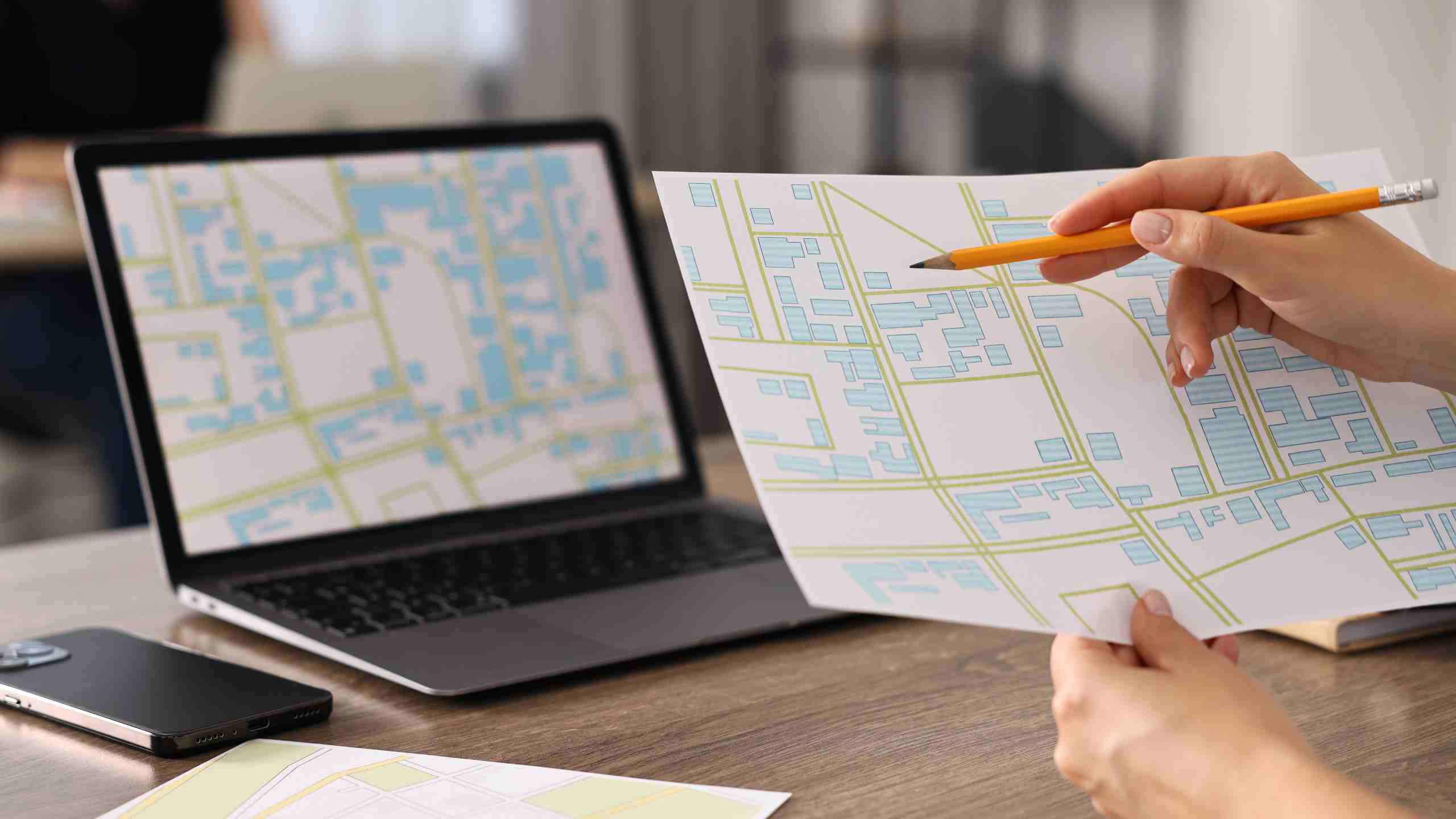
Map Creation: Developing digital maps that visualize spatial patterns and trends.
-
Data Management: Ensuring the accuracy, consistency, and security of spatial databases.
-
Reporting: Preparing detailed reports and visual presentations to support project proposals and policy decisions.
-
Technology Integration: Leveraging emerging technologies like AI and machine learning to enhance spatial data analysis.
Their work is crucial in sectors such as urban planning, environmental science, logistics, and public safety. By providing detailed and accurate spatial information, Geospatial Specialists help organizations make informed decisions that affect communities and the environment.
2.2 Required Skills and Competencies
To succeed in a Geospatial Specialist Career, professionals need to possess a blend of technical and soft skills:
-
Technical Proficiency: Mastery of GIS software (e.g., ArcGIS, QGIS), remote sensing tools, and database management.
-
Analytical Skills: Ability to interpret complex spatial data and identify trends.
-
Attention to Detail: Ensuring high accuracy in data collection and mapping.
-
Communication: Effectively presenting technical information to non-technical audiences.
-
Problem-Solving: Applying innovative solutions to overcome data challenges and improve mapping accuracy.
These skills are typically honed through a combination of formal education, on-the-job training, and continuous professional development.
2.3 Education and Certification Pathways
A career as a Geospatial Specialist usually begins with a degree in geography, geoinformatics, environmental science, or a related field. Many professionals also pursue certifications such as the Geographic Information Systems Professional (GISP) certification or Esri Technical Certifications to enhance their credentials. Continuing education is vital as the field is continuously evolving with new technologies and methodologies.
For further details on educational opportunities and certifications, the Urban and Regional Information Systems Association (URISA) offers valuable resources and professional guidance.
3. Role of a Cartographer
Cartographers are the artists and scientists of mapping. They combine creativity with technical expertise to design and produce maps that are both functional and visually appealing.
3.1 Core Responsibilities
The primary responsibilities of a cartographer include:
-
Map Design and Production: Creating detailed and accurate maps using both traditional and digital methods.
-
Data Visualization: Transforming raw spatial data into clear and informative visual representations.
-
Field Data Collection: Gathering geographical data from various sources, including field surveys and remote sensing.
-
Quality Assurance: Ensuring that maps meet specific standards and accurately represent the spatial data.
Cartographers work in diverse sectors such as education, publishing, government agencies, and private consulting firms. Their work not only supports navigation and location-based services but also contributes to research and policy development.
3.2 Tools and Technologies
Modern cartographers rely on advanced tools and software to create their maps. These include:
-
GIS Software: Platforms like ArcGIS and QGIS are essential for processing spatial data.
-
Remote Sensing Tools: High-resolution satellite imagery and aerial photographs are used to capture detailed geographic information.
-
Design Software: Programs like Adobe Illustrator are often used to enhance the visual appeal of maps.
-
Data Analysis Tools: Statistical software helps cartographers interpret spatial trends and patterns.
These tools allow cartographers to create maps that are not only accurate but also tailored to the specific needs of their audience.
3.3 Educational Background and Career Path
A career in cartography typically requires a degree in geography, cartography, or a related field. Specialized programs in geospatial studies provide the technical training necessary for modern mapping practices. Professional cartographers often participate in internships or apprenticeships to gain hands-on experience with the latest mapping technologies.
Professional organizations such as the International Cartographic Association (ICA) offer networking opportunities, industry insights, and continued professional development, all of which are valuable for those pursuing a Geospatial Specialist Career with a focus on cartography.
4. Role of a LiDAR Specialist
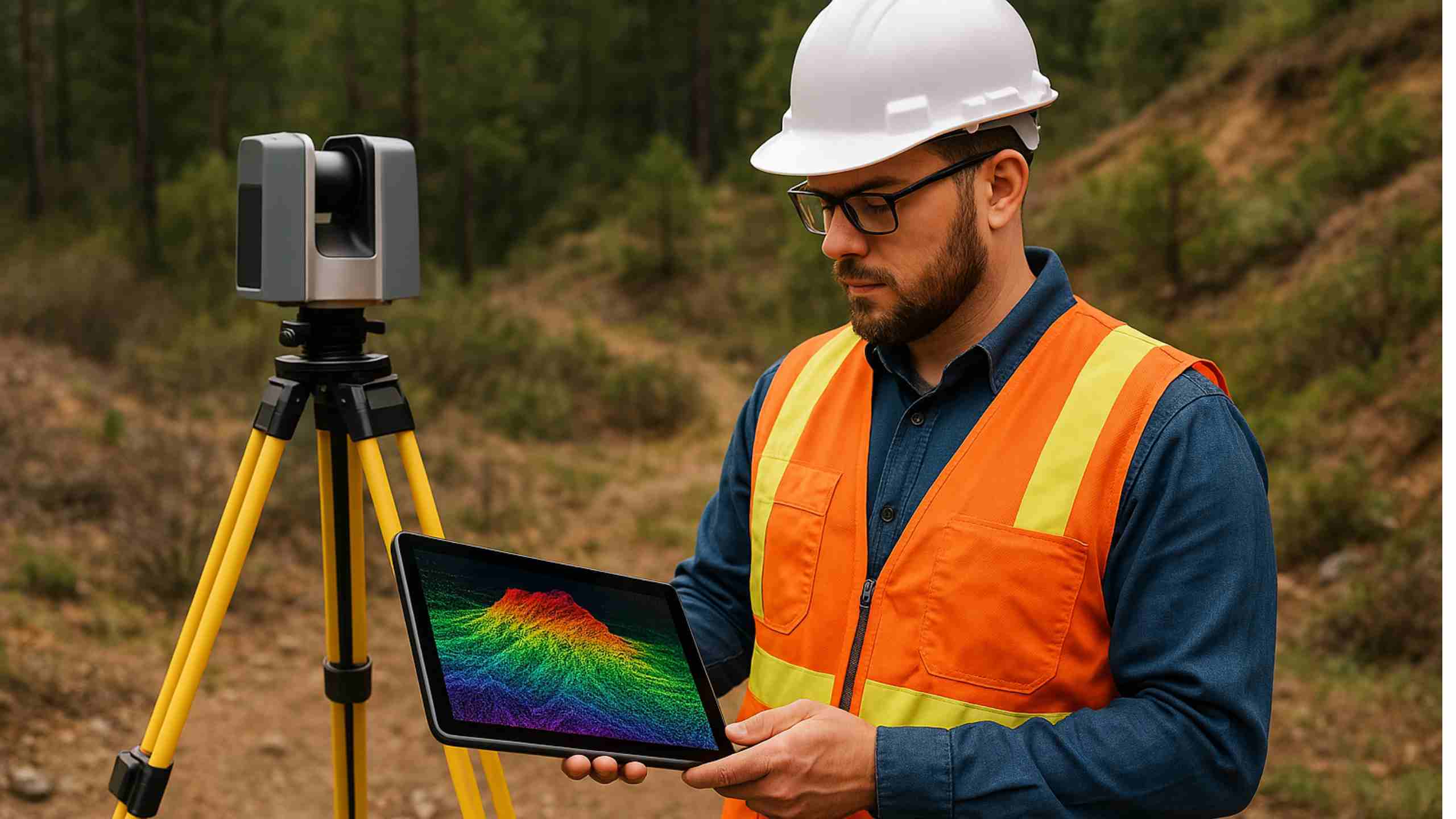
LiDAR (Light Detection and Ranging) technology has transformed the way we collect and analyze spatial data. A LiDAR Specialist is responsible for operating, maintaining, and analyzing data from LiDAR sensors to generate highly accurate three-dimensional maps.
4.1 Understanding LiDAR Technology
LiDAR is a remote sensing method that uses light in the form of a pulsed laser to measure distances to the Earth. This technology is capable of producing precise, three-dimensional information about the shape of the Earth and its surface characteristics. LiDAR data is used in various applications including topographic mapping, forestry management, archaeology, and urban planning.
4.2 Key Responsibilities
A LiDAR Specialist’s responsibilities include:
-
Operation of LiDAR Equipment: Setting up and calibrating LiDAR sensors on aircraft, drones, or ground-based systems.
-
Data Collection: Capturing high-resolution spatial data over large areas.
-
Data Processing and Analysis: Using specialized software to convert raw LiDAR data into usable maps and models.
-
Quality Control: Ensuring the accuracy and reliability of LiDAR data through rigorous testing and validation.
-
Integration with GIS: Merging LiDAR data with other geospatial datasets for comprehensive spatial analysis.
4.3 Skills and Technical Expertise
To excel as a LiDAR Specialist, professionals must possess:
-
Technical Knowledge: Familiarity with LiDAR hardware, data processing techniques, and software tools such as LAStools, Global Mapper, and ArcGIS.
-
Analytical Skills: Ability to process large datasets and extract meaningful information.
-
Attention to Detail: Ensuring that the data collected is precise and free of errors.
-
Problem-Solving: Innovatively addressing challenges related to data quality and integration.
Given the advanced nature of LiDAR technology, a strong foundation in both geospatial science and computer programming can be highly beneficial.
4.4 Career Opportunities
LiDAR Specialists are in high demand across multiple industries. Their expertise is crucial in sectors such as:
-
Environmental Monitoring: Mapping forest canopies and tracking changes in landforms.
-
Infrastructure Development: Assisting in the planning and construction of roads, bridges, and urban developments.
-
Archaeology: Uncovering hidden historical sites by penetrating dense vegetation.
-
Disaster Management: Providing accurate terrain models for flood risk assessments and emergency response planning.
For additional insights into LiDAR technology and its applications, you can explore detailed resources available at the United States Geological Survey (USGS).
5. Mapping Technologies for Accurate Site Analysis
Accurate site analysis is the cornerstone of successful projects in many fields. Advanced mapping technologies enable professionals to collect, analyze, and interpret data with high precision, ensuring that decisions are based on reliable information.
5.1 Geographic Information Systems (GIS)
GIS is one of the most powerful tools for spatial analysis. By integrating hardware, software, and data, GIS allows users to capture, manage, analyze, and display geographically referenced information. GIS platforms such as ArcGIS and QGIS are widely used by geospatial professionals for:
-
Spatial Data Management: Organizing vast amounts of data for easy access and analysis.
-
Visualization: Creating layered maps that represent various data points, such as demographic information, environmental factors, and infrastructure details.
-
Predictive Modeling: Using spatial statistics and AI to forecast trends and potential issues.
The versatility of GIS makes it indispensable for accurate site analysis, providing insights that are critical for urban planning, environmental management, and emergency preparedness.
5.2 Remote Sensing and Satellite Imagery
Remote sensing involves acquiring information about objects or areas from a distance, typically through satellites or aerial vehicles. High-resolution satellite imagery and drone photography provide up-to-date information on land use, vegetation cover, and urban sprawl. These tools are essential for monitoring changes over time and are increasingly integrated with GIS for comprehensive spatial analysis.
5.3 LiDAR and 3D Mapping
As discussed earlier, LiDAR technology offers unparalleled accuracy in capturing three-dimensional spatial data. LiDAR-based maps are used for:
-
Topographic Mapping: Producing detailed elevation models.
-
Vegetation Analysis: Assessing forest structure and biomass.
-
Urban Modeling: Generating 3D models of buildings and infrastructure.
These high-precision maps are crucial for site analysis in areas that require detailed terrain information, such as floodplain mapping and infrastructure development.
5.4 Integration of Mapping Technologies
The future of site analysis lies in the seamless integration of multiple mapping technologies. By combining data from GIS, remote sensing, and LiDAR, professionals can achieve a holistic understanding of a site. This integration leads to more accurate predictions, better risk assessments, and improved decision-making. For more insights into the integration of these technologies, refer to the latest industry trends highlighted on Esri’s blog which discusses emerging trends in geospatial technology.
6. Career Paths in the Geospatial Industry
The geospatial field offers a diverse range of career opportunities, each with its own unique set of responsibilities, challenges, and rewards. Whether you are interested in data analysis, field work, or advanced technological applications, there is a career path that suits your strengths and interests.
6.1 Entry-Level Positions
For newcomers to the industry, entry-level positions often include roles such as:
-
GIS Technician: Focuses on data entry, basic spatial analysis, and map production.
-
Junior Cartographer: Assists in the design and creation of maps.
-
Field Surveyor: Collects data through on-site surveys, often using GPS and remote sensing tools.
These roles provide a solid foundation in geospatial principles and offer opportunities to learn the intricacies of data collection and analysis.
6.2 Mid-Level Careers
With experience and further education, professionals can advance to mid-level roles such as:
-
GIS Analyst: Specializes in complex spatial data analysis, modeling, and visualization.
-
Senior Cartographer: Oversees map production projects and leads design initiatives.
-
LiDAR Data Analyst: Focuses on processing and analyzing LiDAR data, ensuring high levels of accuracy and precision.
At this stage, professionals are expected to have a deeper understanding of geospatial technologies and to demonstrate leadership and project management skills.
6.3 Advanced and Specialized Roles
Advanced positions in the geospatial field offer higher levels of responsibility and specialization:
-
Geospatial Project Manager: Oversees large-scale projects, coordinating between different teams and ensuring that all spatial data requirements are met.
-
Remote Sensing Specialist: Focuses on the acquisition and interpretation of remote sensing data to support environmental and urban projects.
-
Chief Geospatial Officer: A leadership role responsible for setting strategic direction and overseeing the integration of geospatial technologies within an organization.
Pursuing advanced roles often requires a combination of extensive work experience, specialized training, and advanced degrees such as a Master’s or Ph.D. in geospatial sciences or related fields.
6.4 The Role of Certifications and Continuous Learning
In a technology-driven field, continuous learning is essential. Professional certifications not only validate your skills but also enhance your career prospects. Some popular certifications include:
-
GIS Professional (GISP) Certification: Recognizes expertise in GIS and spatial data management.
-
Esri Technical Certifications: Offered by one of the leading GIS software providers, these certifications cover various aspects of GIS and remote sensing.
-
Certified Mapping Scientist: Focuses on the technical and analytical aspects of cartography and geospatial data analysis.
Professional organizations such as the Urban and Regional Information Systems Association (URISA) and the American Society for Photogrammetry and Remote Sensing (ASPRS) provide excellent resources, training, and networking opportunities for those pursuing a Geospatial Specialist Career.
7. Essential Skills and Qualifications
Success in the geospatial field requires a blend of technical expertise, analytical abilities, and strong communication skills. Below are some key skills and qualifications that are vital for a thriving career in this dynamic industry.
7.1 Technical Skills
-
GIS Proficiency: Expertise in GIS software like ArcGIS, QGIS, and GRASS GIS is fundamental. Familiarity with database management and spatial data manipulation is crucial.
-
Remote Sensing: Understanding how to acquire and analyze data from satellite imagery, aerial photography, and LiDAR is essential.
-
Programming and Automation: Knowledge of programming languages such as Python, R, or JavaScript can significantly enhance your ability to automate tasks and develop custom analytical tools.
-
Data Visualization: The ability to transform complex spatial data into clear, informative maps and visualizations is highly valued.
-
Geospatial Software and Tools: Proficiency with industry-standard tools and emerging technologies is important to remain competitive.
7.2 Analytical and Problem-Solving Skills
-
Data Analysis: Ability to interpret spatial data and extract actionable insights.
-
Critical Thinking: Evaluating data quality, identifying trends, and applying innovative solutions to real-world challenges.
-
Attention to Detail: Ensuring data accuracy and precision is essential in all aspects of geospatial work.
7.3 Communication and Collaboration
-
Report Writing: The ability to write clear and concise reports that explain technical findings to non-specialist audiences.
-
Presentation Skills: Proficiency in delivering presentations that effectively communicate complex data insights.
-
Team Collaboration: Geospatial projects often require working with multidisciplinary teams, so strong interpersonal and teamwork skills are crucial.
7.4 Educational Background
A solid educational foundation is critical. Degrees in geography, geoinformatics, environmental science, or related fields provide the necessary theoretical and practical knowledge. Advanced degrees and specialized certifications further enhance a candidate’s expertise and career prospects.
8. Future Trends and Innovations in Geospatial Careers
The geospatial industry is undergoing rapid transformation driven by technological advancements and increasing demand for spatial data analysis. Understanding future trends can help professionals position themselves for long-term success.
8.1 Integration of Artificial Intelligence and Machine Learning
AI and machine learning are increasingly being integrated into geospatial analysis. These technologies enable:
-
Automated Feature Extraction: AI algorithms can identify patterns in spatial data, such as roads, buildings, and natural features, more efficiently than manual methods.
-
Predictive Analytics: Machine learning models help forecast environmental changes, urban growth, and other trends based on historical data.
-
Enhanced Data Processing: Automation reduces the time and cost associated with processing large geospatial datasets.
8.2 The Rise of Unmanned Aerial Vehicles (UAVs)
Drones equipped with high-resolution cameras and LiDAR sensors are becoming invaluable in collecting real-time spatial data. UAVs offer:
-
Cost-Effective Data Collection: They provide a low-cost alternative to traditional aerial surveys.
-
Access to Remote Areas: Drones can easily survey areas that are difficult or dangerous to reach.
-
Rapid Data Acquisition: Real-time data collection accelerates the process of site analysis and decision-making.
8.3 Cloud Computing and Big Data Analytics
The ability to process and store massive amounts of spatial data has been greatly enhanced by cloud computing technologies. Benefits include:
-
Scalability: Cloud platforms allow organizations to scale their data processing capabilities based on demand.
-
Collaboration: Data stored in the cloud can be easily shared among teams, fostering collaborative analysis.
-
Real-Time Processing: Big data analytics enables real-time decision-making in fields such as disaster management and urban planning.
8.4 The Growing Demand for Sustainability and Smart Cities
Sustainability initiatives and smart city projects are increasingly reliant on accurate spatial data. Geospatial professionals are needed to:
-
Monitor Environmental Changes: Track and analyze data related to climate change, pollution, and resource management.
-
Plan Smart City Infrastructure: Develop efficient transportation, energy, and waste management systems.
-
Support Renewable Energy Projects: Map potential sites for solar, wind, and other renewable energy installations.
These trends indicate a bright future for those pursuing a Geospatial Specialist Career, with opportunities to work on projects that have a significant societal impact.
9. Tips for Building a Successful Geospatial Career
For those looking to enter or advance in the geospatial field, here are some practical tips to build a robust and successful career:
9.1 Gain Hands-On Experience
-
Internships and Co-ops: Seek internships in government agencies, private firms, or non-profit organizations that focus on geospatial projects.
-
Field Work: Engage in field data collection projects to gain practical experience with the tools and techniques used in the industry.
-
Projects and Competitions: Participate in mapping competitions or open-source projects to showcase your skills.
9.2 Stay Updated with Technological Advancements
-
Continuous Learning: Enroll in courses and certifications to stay current with the latest software and methodologies.
-
Networking: Join professional organizations such as URISA and ASPRS to connect with industry experts and peers.
-
Conferences and Workshops: Attend industry conferences and workshops to learn about emerging trends and best practices.
9.3 Develop a Strong Online Presence
-
Portfolio: Create an online portfolio that showcases your projects, maps, and technical skills.
-
LinkedIn Profile: Optimize your LinkedIn profile using keywords like Geospatial Specialist Career to attract recruiters and employers.
-
Personal Blog: Consider starting a blog where you share insights, tutorials, and case studies related to geospatial technologies.
9.4 Enhance Your Soft Skills
-
Effective Communication: Work on your writing and presentation skills to clearly articulate technical concepts.
-
Team Collaboration: Develop the ability to work in diverse teams, as many geospatial projects involve multidisciplinary collaboration.
-
Problem-Solving: Emphasize your ability to tackle complex challenges with innovative solutions.
10. The Impact of Mapping Technologies on Various Industries
Mapping technologies are not confined to traditional sectors; they have a transformative impact across numerous industries.
10.1 Urban Planning and Infrastructure
Accurate maps are essential for designing efficient transportation systems, optimizing land use, and planning urban development. Geospatial data helps identify traffic patterns, assess infrastructure needs, and plan public services.
10.2 Environmental Management
From tracking deforestation to monitoring water quality, geospatial technologies enable environmental scientists to conduct detailed analyses of ecological changes. Mapping plays a crucial role in conservation efforts and sustainable resource management.
10.3 Disaster Management and Emergency Response
Real-time spatial data is invaluable during emergencies. Mapping technologies help emergency responders identify the most affected areas, plan evacuation routes, and allocate resources effectively. This role has become even more critical as climate change increases the frequency of natural disasters.
10.4 Business and Marketing
Businesses use geospatial analysis for market research, location-based advertising, and supply chain optimization. Mapping customer demographics and competitor locations allows companies to make data-driven decisions that improve their bottom line.
11. Case Studies and Real-World Applications
Understanding the practical applications of geospatial technologies can provide valuable context for those considering a career in this field. Below are a few case studies that highlight the impact of mapping technologies in real-world scenarios:
11.1 Urban Redevelopment Projects
In many cities, geospatial data has been used to revitalize urban areas. For instance, comprehensive GIS analysis helped local governments identify underutilized land and plan mixed-use developments. This approach not only improved urban aesthetics but also boosted economic growth.
11.2 Environmental Conservation Efforts
LiDAR technology has been instrumental in environmental conservation projects. Detailed 3D mapping of forest canopies and river systems has enabled researchers to monitor the effects of climate change and human activity on delicate ecosystems. These projects demonstrate how a Geospatial Specialist Career can directly contribute to sustainability and environmental protection.
11.3 Disaster Response and Recovery
During natural disasters, such as hurricanes and earthquakes, rapid deployment of drones equipped with LiDAR sensors has allowed emergency management teams to assess damage quickly. The data collected has been used to guide rescue operations and prioritize recovery efforts, underscoring the life-saving potential of advanced mapping technologies.
12. How to Transition into a Geospatial Specialist Career
For professionals considering a career change or fresh graduates seeking entry into the geospatial field, here are some actionable steps:
12.1 Assess Your Current Skills
Identify your current strengths and areas for improvement. Whether you come from a background in IT, environmental science, or urban planning, many of your skills are transferable to a geospatial context.
12.2 Enroll in Specialized Courses
Online platforms and local universities offer courses in GIS, remote sensing, and cartography. Courses provided by reputable organizations like Esri Academy can provide you with the necessary technical skills.
12.3 Build a Portfolio
Start working on personal projects or volunteer with community mapping initiatives. A well-documented portfolio showcasing your work with GIS, cartography, or LiDAR data can be a valuable asset when applying for jobs.
12.4 Network with Professionals
Join online forums, attend industry meetups, and participate in webinars to connect with experienced professionals. Networking can provide mentorship opportunities and may open doors to job openings in the geospatial field.
Conclusion
The geospatial field is a dynamic and ever-expanding arena that offers exciting career opportunities for those passionate about technology, data analysis, and spatial science. Whether you choose to pursue a career as a Geospatial Specialist, Cartographer, or LiDAR Specialist, the skills and knowledge you acquire will enable you to play a crucial role in shaping the future of our built and natural environments.
The integration of advanced mapping technologies, such as GIS, remote sensing, and LiDAR, is revolutionizing how we analyze and interact with our world. From urban planning and environmental conservation to disaster management and business analytics, the applications of geospatial data are vast and varied. As organizations increasingly rely on precise spatial data for decision-making, the demand for professionals with expertise in geospatial technologies continues to grow.
For anyone considering a Geospatial Specialist Career, the prospects are promising. With a strong foundation in technical skills, continuous learning, and an eye for innovative solutions, you can make significant contributions to projects that drive societal change and improve quality of life. Moreover, the opportunities to work in diverse industries and across various disciplines make this an exciting and fulfilling field to enter.
In today’s digital age, the need for accurate site analysis and spatial data interpretation is more critical than ever. Whether you are mapping urban landscapes, analyzing environmental impacts, or planning for future infrastructure, the role you play as a geospatial professional is invaluable. By staying updated with the latest technologies and industry trends, you can ensure that your skills remain relevant and that you continue to deliver high-quality insights.
As you consider your future in this field, remember that a successful career in geospatial sciences is built on a combination of technical expertise, practical experience, and a commitment to continuous learning. Embrace opportunities for professional growth, seek out mentorship, and never stop exploring new technologies that can further enhance your capabilities.
For more information on advancing your skills and exploring career opportunities in the geospatial industry, refer to reputable sources such as ESRI’s Resources and USGS’s Mapping Technologies. These platforms offer a wealth of information, training materials, and industry insights that can help guide your journey.
Final Thoughts
The careers of Geospatial Specialists, Cartographers, and LiDAR Specialists are not just jobs—they represent a commitment to understanding and improving the way we perceive and interact with our world. The challenges in these roles are many, but so are the opportunities. As technology continues to advance and our need for detailed spatial data grows, those who choose to pursue a Geospatial Specialist Career will find themselves at the forefront of innovation and societal impact.
By harnessing the power of mapping technologies for accurate site analysis, you can contribute to projects that not only advance industry standards but also create lasting, positive change in communities around the globe. Whether you are just starting out or looking to take your career to the next level, the path ahead is filled with potential. Embrace the challenges, stay curious, and let your passion for geospatial science drive you toward a future rich with opportunity.
For additional articles, case studies, and the latest industry news, be sure to follow our blog and subscribe to our newsletter. Your journey into the world of geospatial science starts here—explore, learn, and transform your career with the power of spatial data.
By providing detailed insights into each specialized role and highlighting the importance of mapping technologies, this article aims to serve as an invaluable resource for anyone interested in pursuing a Geospatial Specialist Career. With the right blend of technical skills, continuous learning, and practical experience, you can unlock a world of opportunities and make a significant impact on the way we understand and shape our environment.
Embrace the future of geospatial science and join the community of professionals dedicated to innovative mapping and spatial analysis. Whether you are designing detailed maps, analyzing LiDAR data, or developing new geospatial applications, your work will help build smarter, more sustainable, and more resilient communities.
Related Posts:
- Geographic Information Systems (GIS) Specialization Online Course
- Blending GIS & BIM: A Novel Approach In Infrastructure Development
- The Difference Between Surveying and Quantity Surveying
- Construction Technologist: Career Path, Skills, Salary & Future Trends [2025 Guide]