
Last Updated on April 18, 2023 by Admin
The fluctuations in construction technology are dramatically sprouting as the construction industry is taking a giant leap towards going digital with many innovations. One of the in-use contemporary techniques is BIM (Building Information Modeling), becoming a crucial tool for digital construction. This article discusses the blending of GIS and BIM.
ConstructionCareerHub App is LIVE — built ONLY for construction careers. Don’t apply with a weak resume.
Get ATS-ready Resume Lab + Interview Copilot + Campus Placement Prep (resume screening, skill gaps, interview readiness) — in minutes & Other advanced features.
Explore Smarter Construction Career Tools →Quick check. Big impact. Start now.
The term BIM was first coined in 1992 yet evolved at different paces worldwide; in 2002, AEC (The Architecture, Engineering, And Construction) industry recognized this field for anticultural and constructional disciplines.
Related Posts:
- Ebook on Building Information Modeling (BIM): An Ultimate Career Guide
- BIM | Building Information Modeling | A Great Career Option For Engineers
- Building Information Modelling (BIM) Free Online Courses [2021 Updated]
- Autodesk Revit BIM Software Online Tutorials and Courses [2021 Updated]
- What are the Uses and Benefits of BIM in Construction Project?
- The Best BIM Companies in Pune [2021 Updated List]
Table of Contents
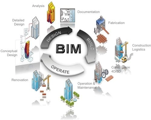
Do you know what BIM is?
BIM is a computational three-dimensional illustration of generating, distributing, transforming, transposing, manipulating, and managing selective information about different structures such as buildings, railway structures, roads, bridges, and tunnels on all accounts of its life span from designing, construction and development, to operation, maintenance and demolishing phases.
What do you know about GIS?
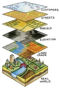
Geographic information system (GIS) is a computerized framework used widely to map and analyze problem-oriented spatial pieces of information, including infrastructure projects, to manage, alter, conceptualize, examine and portray geographic information based on geometric methods.
Over the years, GIS has been working with 2D mapping techniques. Still, now, with technological innovations, 3D maps are in trend for complex spatial data analysis procedures and documentation and visualization, facilitating a quick decision-making process.
Site determination for urban planning, disaster risk management, environmental monitoring, and land assessment is one of the striking examples of such applications in GIS for construction projects.
The dire need to blend GIS and BIM, but why?
Generally, BIM is polished with comprehensive information on both geometry and semantics of physical structures over the years; even so, it lacks information about the surroundings. Therefore,
The inadequate spatial information needed by BIM for the course of action, security investigation, realistic assessment, and ecological effect examination, for example, geological data of a region, which is fundamental to the spatial arrangement of dam construction, are only contained in GIS.
Thus, the integration of GIS and BIM benefits the construction industry, filling the gaps in infrastructure planning, construction, and operational processes. Seeing that GIS focuses on the physiographic information of structures in terms of the environment, primarily as it presently exists and its other features from topographical perspectives.
On the contrary, BIM emphasizes complex structures and venture data like the plan, design, and development of building locales.
Due to this blending, it is broadly recognized that incorporating information from both domains is beneficial and crucial to flourish future 3D modeling techniques practically utilizing two distinctive most famous data exchange formats—for example, City Mark-up language (CityGML) and Industrial establishment class (IFC), accordingly.

How does the integration work?
The merger of BIM and GIS is the fusion technique of the BIM model into layers of the geospatial settings. Via georeferencing and design concepts in the BIM, the building sector is preparing efficient designs.
Although the two areas were separately introduced for different reasons and to act on distinct platforms, they favor each other through information trading.
For instance, GIS can give knowledge on flood-inclined zones, providing engineers with precise data to impact a construction’s location, direction, also constructional supplies.
BIM helps design an object-oriented physical structure, for example, drawing a gate, a window, or a fence. So, by adding a layer into GIS settings, the context of the structure becomes more competent on the broader landscape.
GIS offers services on larger scales, such as local, regional, and national levels. That’s why a structure will be associated with a package of land, utilities, and streets.
Workflow Steps and Software used.
- To enable the valuation of CAD/BIM designs and for planning setups dependent on the existing GIS information grid, ETL (Extract Transform Load) technique using FME (Feature Manipulation Engine) technology is applied.
- For 2D and 3D GIS information handling, examination, and representation, ArcMap/ArcGIS Pro with Data Interoperability Extension is utilized.
- Intended for 3D procedural modeling, and exporting CGA (Computer-generated Architecture) rule, use City-Engine in ArcGIS Pro.
- Preliminary procedures must be performed before any GIS analysis, for example, topology validation, data enrichment, and formation of 3D geometries using ArcGIS.
- Autodesk Revit, Autodesk AutoCAD, Solibri Model Checker, Linear Project TILOS, and RIB iTWO can be practiced for architectural modeling.
- In ArcMap, CAD data can be opened directly for further analysis after being validated and fixed. It is then transformed into polygons and saved into ArcMap’s geodatabase.
- The Esri data interface extension facilitates the data flowing from both domains. IFC data format of BIM is converted to Esri multi-patch stored in a geodatabase. The resultant information is then stacked in GIS as a layer to be utilized for examination.

Benefits of the blend
BIM and GIS do not just assist plan and development groups efficiently. However, they likewise empower the information made during those cycles to utilize a broad scope of operations and maintenance processes, such as facilities management, space planning, and security.
There exist several benefits from integrating BIM and GIS, including the following:
- Maximize profits on currents investments in BIM and GIS software to extend the return on investment.
- Strengthen the understanding of projects within the context of their location, what is built, and broaden environmental, demographic, economic, and other factors.
- Support collaborative work plans to minimize data loss and limit inefficiencies.
- Make better-informed decisions to boost project delivery and enhance the operations and maintenance of accomplished ventures.
- Support architects, engineers, and GIS teams work together more effectively to put data at the center, remove silos, and connect workflows.
- Empower planners and engineers to design more intelligent, efficient, and environmentally friendly buildings and infrastructure; help understand the impacts of these structures on the ecosystem; gather and investigate field data. And improve communication with relevant participants.
- Link existing information to create a federated source of factual data that helps minimize costly errors and delays regarding critical design decisions.
Common myths about GIS and BIM Integration
In a nutshell, the five myths and truths are:
BIM is only for 3D Modelling
There is some misconception in the GIS community about the role of BIM. It is not for 3D Building modeling only as the B in BIM stands for ‘Building, the verb’ not ‘Building, the noun, so what it is for is directly relevant to driving the value of GIS data workflows in the BIM process.
BIM automatically provides GIS features
BIM does not provide many of the features that we need to see in GIS for facilities and resource management workflows. We can get them, but it takes to process and standards as well as technology.
BIM-GIS integration is based on file formats
BIM-GIS blending is needed for a complex process integrating capital portfolio management and engineering project delivery. Sophisticated technologies are needed for integration mapping to realize the total value of integrating BIM and GIS data and workflows.
BIM content can’t be used directly in GIS
BIM content in GIS is used directly; for instance, Autodesk Revit content in ArcGIS Pro can be used in a tick. The new Building Scene Layer extends the capability to the web.
GIS act as a prime repository for BIM information
GIS is typically not going to be the legal source of record for project documentation. It must be assured to meet the workflow needs of clients, providing them access to GIS and BIM data repositories. Kindly check this list of the top 15 best BIM software.
For more collaborations and exciting topics, please visit GISTeck.de https://gisteck.de/. For further queries, feel free to contact us.
Author: Maria Riffat (Founder of GISTeck- https://gisteck.de/team/)