
Last Updated on January 21, 2026 by Admin
Construction projects succeed or fail based on the quality of information available to the people making decisions. Every survey, inspection, and progress report influences safety planning, budget control, and delivery timelines. As construction sites grow larger and more complex, traditional methods of collecting this information are increasingly stretched.
ConstructionCareerHub App is LIVE — built ONLY for construction careers. Don’t apply with a weak resume.
Get ATS-ready Resume Lab + Interview Copilot + Campus Placement Prep (resume screening, skill gaps, interview readiness) — in minutes & Other advanced features.
Explore Smarter Construction Career Tools →Quick check. Big impact. Start now.
In 2026, drone services in construction will be widely used because they solve practical problems. They provide a clear, accurate view of site conditions without slowing work or placing people in unsafe positions.
Across many active sites today, drone services in construction are being used simply as a clearer way to understand real conditions on the ground, helping teams replace assumptions with accurate, up-to-date visual information.
Rather than relying only on manual measurements or visual checks from the ground, construction teams can now use aerial data to understand what is really happening across an entire site.
This shift is not about technology for its own sake. It reflects a growing need for better visibility, consistent documentation, and reliable data that support everyday decisions. Drones have become tools for clarity, helping teams reduce uncertainty and manage risk throughout the construction process.
Table of Contents
Why Drone Services Matter in Modern Construction
Construction today operates under constant pressure. Deadlines are tight, labor is limited, and safety expectations are higher than ever. Traditional surveys and inspections often require site access restrictions, scaffolding, or specialized equipment, which can interrupt work and increase costs.
Drone services address these challenges by allowing data to be collected quickly and consistently from above. A single flight can capture site-wide conditions that would otherwise take days to document manually. This speed allows teams to respond faster when issues arise and to plan work with greater confidence.
Safety is another major factor. Many inspection tasks involve working at height or near moving equipment. Using drones to observe these areas reduces exposure to hazards while still delivering the information engineers and managers need to make informed decisions.
Surveying and Mapping Applications
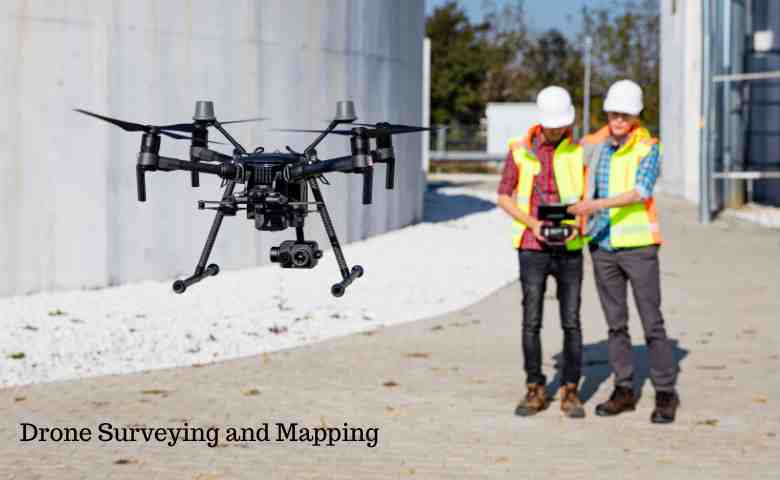
One of the most established uses of drones in construction is site surveying and mapping. Using photogrammetry and LiDAR surveys, drones generate detailed topographic maps, 3D surface models, and volume calculations.
These outputs are used for grading plans, drainage design, access planning, and earthworks management. Compared to ground-based surveys, drone mapping covers larger areas in less time and with minimal disruption to ongoing activities.
Accuracy is a key advantage. Consistent data collection improves confidence in measurements, supporting better planning and reducing the likelihood of costly adjustments later in the project.
Construction Progress Monitoring
Tracking progress accurately is essential for keeping projects on schedule. Drone flights conducted at regular intervals create a visual timeline of how a site changes over time.
These records allow project managers to verify completed work, identify delays, and coordinate trades more effectively. They are also useful for keeping clients and stakeholders informed without requiring frequent site visits.
Because the imagery is time-stamped and consistent, it provides an objective reference that helps resolve disagreements and supports transparent reporting.
Safety and Condition Inspections
Drones are widely used for inspections that would otherwise require workers to operate at height or in difficult conditions. Roofs, façades, bridges, towers, and scaffolding can be inspected using high-resolution cameras and zoom lenses.
Thermal inspections add further insight by revealing moisture intrusion, insulation failures, and electrical issues that are not visible to the naked eye. These inspections can be carried out without shutting down operations or installing temporary access structures.
By reducing the need for manual inspections in hazardous areas, drones contribute to safer sites and lower risk exposure.
Quality Control and Verification
Quality control relies on understanding whether construction work matches design intent. Drone data can be compared with drawings or digital models to verify alignment, placement, and completeness.
This approach helps identify issues early, when corrective action is less disruptive and less expensive. It also supports documentation requirements by providing visual evidence of work completed at specific stages.
For projects using Scan to BIM workflows, accurate aerial data supports reliable models that reflect real site conditions rather than assumptions.
Operational Benefits for Construction Teams
The practical benefits of drone services are reflected in daily operations. Faster access to information allows teams to make decisions based on current conditions rather than outdated reports.
Cost savings result from reduced survey time, fewer site disruptions, and early detection of issues. Improved accuracy reduces rework, while safer inspection methods lower the risk of accidents.
Clear visuals improve communication across teams, helping everyone work from the same understanding of site conditions.
Integration with Digital Construction Workflows
Drone data integrates effectively with GIS, CAD, and BIM systems used throughout the construction industry. Survey outputs support design coordination, while progress data feeds into scheduling and reporting tools.
In Scan to BIM applications, point clouds and imagery are used to create as-built models that support coordination during construction and asset management after completion.
This integration ensures that aerial data contributes value throughout the project lifecycle.
Compliance and Data Management
Professional drone operations follow aviation regulations such as FAA Part 107 or equivalent standards in other regions. Compliance ensures that flights are conducted safely and legally.
Equally important is data handling. Construction projects often involve sensitive commercial or public infrastructure information. Secure storage, controlled access, and clear data ownership practices help protect this information and maintain trust.
Reliable data management ensures that drone outputs can be confidently used for engineering, planning, and reporting purposes.
Challenges and Practical Considerations
While drone services provide clear benefits, they require thoughtful planning. Weather conditions can affect flight schedules, and large datasets must be processed correctly to be useful.
Regulatory restrictions may limit operations in certain areas, particularly near airports or urban centers. Understanding these constraints helps teams plan realistic data collection schedules.
Working with experienced operators who understand construction requirements helps mitigate these challenges.
Future Direction of Drone Use in Construction
Drone use in construction continues to evolve. Advances in automation and data analysis are making inspections more efficient and consistent.
Expanded permissions for longer-range flights will support monitoring of larger sites and infrastructure corridors. As digital construction practices mature, aerial data will play an even greater role in planning, monitoring, and maintenance activities.
Conclusion
In 2026, drone services are valued for their practicality rather than novelty. They provide clearer visibility, safer inspections, and more reliable documentation across construction projects.
By supporting better decisions and reducing uncertainty, drones help construction teams deliver projects efficiently while maintaining safety and quality standards. Their role is not to replace expertise, but to provide better information for the people responsible for building and maintaining the built environment.
Related Posts:
- Leveraging Drones for Efficient Infrastructure Inspection and Maintenance
- BIM Specialists, Tech Managers, and Drone Operators: The New High-Demand Construction Careers
- Sustainability In Construction: Best Practices And Trends
- Top Construction Roles in 2025: New Skills, Certifications, and Specializations
- Drone Roof Inspection: Efficiency and Safety Revolution